
2nd Apr 2026, 12:23 PM
SMA20 Base 900MHz GNSS RTK GPS Surveying Equipment 1408 Channels, Work as Base Station for UAVs /Drones, Land Survey, Topographic Mapping, CORS /NTRIP Correction, Free Software, NOAA Certified
Price may vary by location, shipping cost, and availability.
Lowest in last 1 year
$1,083.00
Highest: $1,383.00
Average: $1,104.05
Lowest: $1,083.00
Lowest Offer: $920.55
Price History Graph
Offer Price Prices
Lowest: -
Average: -
Highest: -
Price History Information
You can check the price history of SMA20 Base 900MHz GNSS RTK GPS Surveying Equipment 1408 Channels, Work as Base Station for UAVs /Drones, Land Survey, Topographic Mapping, CORS /NTRIP Correction, Free Software, NOAA Certified here. This product's current Price in USA is $1,083.00 and the lowest final price is $920.55. The average and highest prices are $1,104.05 and $1,383.00 respectively.
| Lowest Ever Offer Price | $920.55 |
|---|---|
| 1st Feb 2026 | |
| Lowest Ever Price | $1,083.00 |
| 27th Dec 2025 | |
| Average Price | $1,104.05 |
| Based on 590 days price tracking | |
| Highest Price | $1,383.00 |
| 22nd Mar 2025 | |
Price History of All Variants of SMA20 Base 900MHz GNSS RTK GPS Surveying...


Current Price in USA
| Price | $1,083.00 |
|---|
Recent Price Drops on SMA20 Base 900MHz GNSS RTK GPS Surveying Equipment 1408 Channels, Work as Base Station for UAVs /Drones, Land Survey, Topographic Mapping, CORS /NTRIP Correction, Free Software, NOAA Certified
Offer Price Drop 31st Jan 2026
$974.70 → $920.55
5.56% drop
Offers: 15% Coupon
Price Drop 26th Dec 2025
$1,383.00 → $1,083.00
21.69% drop
Price Drop 10th Oct 2024
$1,226.00 → $1,103.00
10.03% drop
Product Information
Details
| Product Name | SMA20 Base 900MHz GNSS RTK GPS Surveying Equipment 1408 Channels, Work as Base Station for UAVs /Drones, Land Survey, Topographic Mapping, CORS /NTRIP Correction, Free Software, NOAA Certified |
|---|---|
| Store Product Code | B0DHRDW7WZ |
| Store Name | amazon.com |
| Brand | SMAJAYU |
| Rating | 10 / 10 |
| Category | Antennas |
| Product Manufacturer | SMAJAYU |
| Model Number | SMA20 Rover |
| Model Name | SMA20 Rover-900MHz |
Features
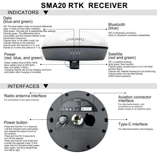
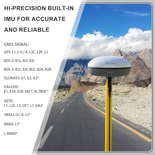
- Advantages: Static and Base dual mode simultaneously works, PPK surveying and PPK calculation on SMA SURVEY APP NOAA certification: SMA20RTK is antenna name of NOAA registered Compatible with SMA26 static for PPK. PPP method: PPP method by Galileo HAS correction; Rinex logging enabled which can export rinex files directly to PC; Ntrip network connection supported by login a CORS account on SMA SURVEY APP
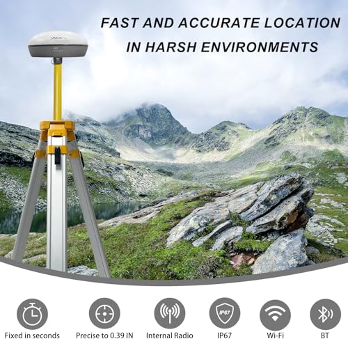
- Capability: Full-Constellation, one GNSS receiver free switching between rover and base station. 1cm RTK accuracy and 0.25cm static accuracy ; 30tilt 2.5cm accuracy (horizontal),max. angle 60tilt, ; long endurance battery:10hours for base under continuous work of each battery charge; 2.5cm accuracy by PPK method; 2.5cm RTK accuracy by Ntrip network station Able to starting with fixed point to make sure higher accuracy
- Multiple Frequency, Offers higher accuracy and Stability,Stronger Resistance,Faster Convergence time Differential technology: RTK, PPP, PPK,Static Supported protocols: TRIMATLK, TRIMMARK Ill, TT450S, TRANSEOT, Satel 3AS 4FSK Frequency: 900Mhz
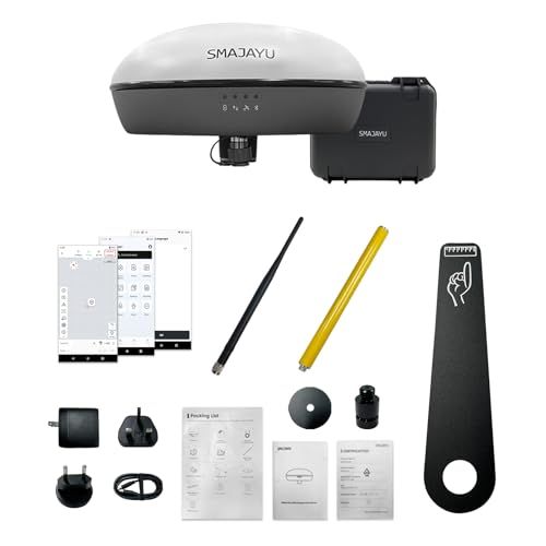
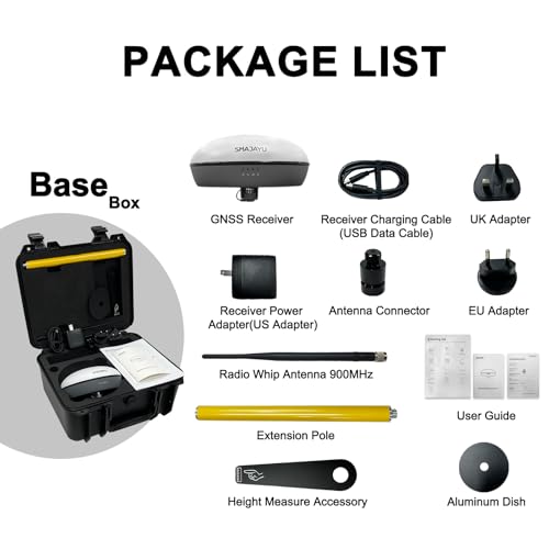
- Packing list Set: One gnss receiver and surveying software for android device(phone,tablet,collector). Excludes collector and tripod Activated "SMA SURVEY" software included and free download.
Images
× ![]()

Rating and Reviews
10 Based on 9 reviews
SMA20 Base 900MHz GNSS RTK GPS Surveying has 10 rating out of 10. This average rating is consist of 9 individual ratings. You can rate this product at product review page.
* Predictions is created on based of past prices and trends, it does not guarantee that it will happen. These are just prediction for theoretical information only.